

Introduction
Revolutionize your real estate photography game by incorporating the power of drones. In this comprehensive guide, we will delve into the art of capturing mesmerizing aerial shots for real estate purposes.
What Is Real Estate Drone Photography?
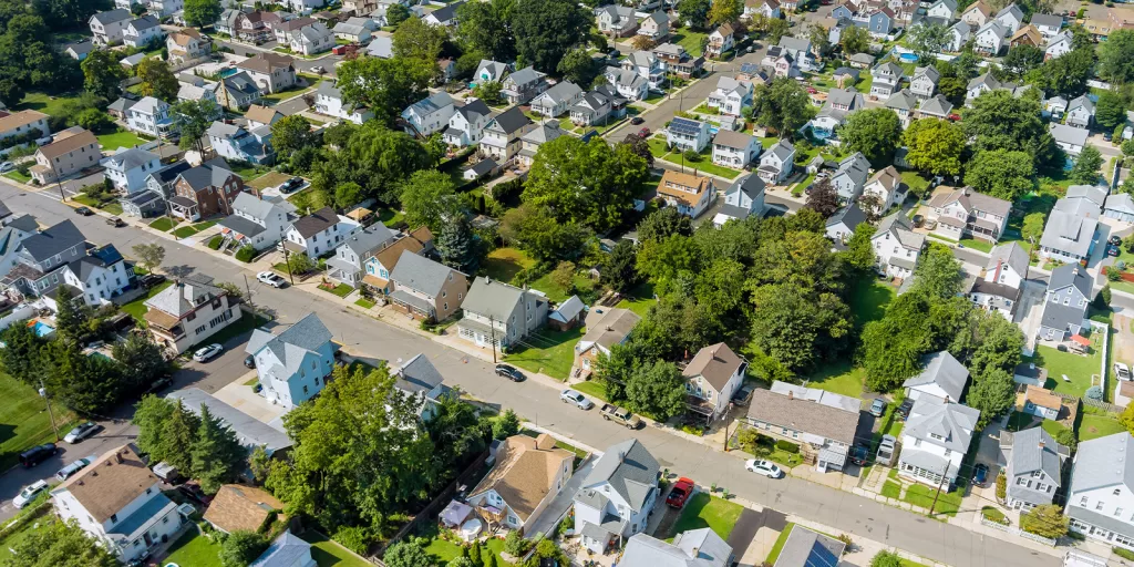
Real estate drone photography entails utilizing drones to capture breathtaking images of properties intended for sale or rent. By employing drones, you can showcase properties from an aerial perspective, enabling potential buyers or renters to gain a comprehensive understanding of the property’s surroundings and allure.
Who Should Engage in Drone Photography?
Thanks to advancements in drone technology, many individuals are harnessing the creative potential of drones for photography. There are two primary methods to undertake real estate drone photography.
One approach involves hiring a professional drone pilot who possesses the necessary expertise. These skilled pilots bring their equipment, adhere to safety regulations, and may offer additional services like image editing. It’s crucial to review a pilot’s portfolio and customer feedback while ensuring they possess the required licensing and insurance.
Alternatively, you can embark on a DIY journey by capturing real estate drone photography yourself. However, keep in mind that flying drones necessitates practice and adherence to specific rules and regulations. Familiarize yourself with local drone usage laws and exercise caution to avoid penalties and potential hazards.
Essential Equipment for Real Estate Drone Photography
To embark on your real estate drone photography venture, you must acquire a camera-equipped drone. Previously a costly pursuit, drone photography has become more accessible as its popularity has soared. When selecting a drone, consider the following aspects:
- Camera quality: Opt for a drone equipped with a high-resolution camera, ideally with 12 megapixels or more.
- Flight stability: Look for drones with built-in gimbals, ensuring smooth flights and sharp, stable images.
- Range: Aim for a drone with a substantial range, enabling flights at a safe distance from your controls.
- Flight duration: The average professional drone offers around 30 minutes of flight time, although longer durations are advantageous.
Choosing the Ideal Drone for Real Estate Photography
When it comes to professional real estate photography, drones like the DJI Phantom 4 Pro and DJI Mavic 3 Pro reign supreme. These models boast outstanding capabilities for capturing high-quality images and videos. Although the DJI Inspire 2 is a viable option, it is primarily optimized for other professional applications.
Budget Considerations for Drone Photography
While entry-level camera drones may seem enticing due to their affordability, it’s important to remember the adage “you get what you pay for.” For satisfactory results in aerial photography, consider slightly more advanced options like the now-discontinued DJI Phantom 3 or Mavic Air. These models strike a balance between cost-effectiveness and acceptable image quality.
Mastering Real Estate Drone Photography: A Step-by-Step Guide
Now that you have your drone, it’s time to take to the skies and hone your skills. Familiarize yourself with the following essentials before embarking on your real estate drone photography journey.
1. Know the Law
Adhere to these crucial guidelines for responsible drone operation:
- Always steer clear of airports, airfields, and aircraft.
- Maintain a safe minimum from people and property.
- Restrict flights to altitudes below 400ft.
Additionally, be aware that drone operation rules may vary between countries and even states within a country. Thoroughly research local regulations, obtain proper training if necessary, and ensure flight clearance. Familiarize yourself with the processes and laws specific to your intended flying location by consulting your country’s civil aviation authority.
2. Research and Practice for Skill Development
Mastering drone piloting requires a learning curve. Seek guidance from available courses dedicated to teaching drone flight intricacies. Alternatively, utilize the vast resources available online for self-study. Before venturing into the field, conduct thorough research. Begin with low-altitude exercises like climbing, hovering, and landing to familiarize yourself with the drone’s capabilities. Gradually increase altitude and start capturing in-flight photos when confident in your skills.
Developing proficiency in drone flying entails honing coordination and spatial awareness. Approach the learning process with patience, and you’ll emerge as a competent pilot.
3. Obtain the Necessary License for Commercial Drone Operation
Once you’ve gained confidence in your drone photography skills, you may consider venturing into real estate photography as a business. This often involves acquiring licenses and permissions to operate a drone business. Regulations governing real estate drone photography vary from country to country. Conduct thorough research to understand the rules and regulations specific to your location and purpose. Cultivate a portfolio of high-quality work by collaborating with real estate agents or photographing properties owned by yourself, friends, and family.
4. Determining Pricing for Drone Photography Services
After establishing a solid portfolio, you can commence charging clients for your services. Real estate drone photography prices typically start at around $150. However, it’s advisable to research local drone photography services to determine the exact pricing norms in your area.
Expert Tips for Outstanding Real Estate Drone Photography
To produce captivating and impactful real estate drone photography, consider the following expert tips:
- Capitalize on Pleasant Weather: Optimal weather conditions enhance the appeal of real estate images. Plan your shoots on calm and clear days to minimize hazards and maximize visual appeal.
- Highlight Property Features and Surroundings: In addition to showcasing the property, emphasize nearby amenities such as parks and cafes. Capture appealing aspects of the surrounding neighborhood to provide potential buyers or renters with a comprehensive understanding of the area.
- Focus on Property Strengths: Exploit the drone’s elevated vantage point to capture the property’s unique features. Angled shots showcasing elements like pools and gardens offer a comprehensive view of the property’s allure.
- Ground-Level Principles Apply: While drone photography is a thrilling field, remember that the fundamentals of ground-level photography remain relevant. Compose your shots skillfully by incorporating elements such as leading lines, the rule of thirds, color, contrast, pattern, and diagonals. Additionally, adjust exposure settings to optimize image quality and ensure a visually pleasing result.
- Capture Abundantly: Leverage the capabilities of drone photography by capturing multiple photos from various angles. This ensures you secure the perfect shot that effectively showcases the property.
The Takeaway
By leveraging the power of drones, you can add a unique perspective to your real estate photography endeavors. Whether you opt to hire a professional drone pilot or venture into drone photography yourself, the sky is the limit. Elevate your real estate visuals and seize the opportunity to captivate potential buyers or renters with stunning aerial imagery.
Be smart, safe, and forever fly!
If you have any questions, let us know! If you’d like to hire us, you can get more information here.
Written by: Tony Marino, MBA – FAA Certified Part 107 Commercial Drone Pilot and Chief Business Strategist at Aerial Northwest
Resources
Federal Aviation Administration (FAA) – Official regulatory body for drone operations in the United States. Their website provides information on drone regulations, certification requirements, and airspace restrictions:
Disclaimer: The information provided in this blog post is for general informational purposes only and should not be construed as legal advice.
DRONE BUSINESS STRATEGY MAGAZINE
A free digital publication made exclusively for all small business drone pilots to them help start-up, become profitable while sustaining a competitive advantage within the drone service industry sector they opt to serve.
“If you love to fly, we’d love to have you come aboard!”
We share your information with no one. Our Privacy Policy.




Leave a Reply
Your email is always safe with us.