Oregon drone pilots can fly in controlled and uncontrolled airspace. There are different requirements depending on which airspace you fly in and where you take off and land.
The Federal Aviation Administration (FAA) is constantly engaged in efforts to promote the safety of the skies. This requires extensive planning and effective communication practices to keep all parties up to date on the latest rules and policy changes related to small Unmanned Aircraft Systems (sUAS). Despite the FAA’s overall control over all airspace in the United States, the public and state legislators have the authority to regulate specific areas as “No Drone Zones” for takeoff and landing locations within their respective states, counties, and cities. This has created some uncertainty regarding where drone pilots in Oregon can legally fly their aircraft while complying with the state’s drone regulations, which are not always well-known or understood.
Flying Drones In Oregon State Parks
At the time of this writing, the Oregon Parks and Recreation Department is conducting UAS Rule Advisory Committee process to help create the rules that will alleviate much of the confusion about which Oregon state parks are flyable and which parks prohibit drone operations altogether.
Oregon Drone Flying Resources
These resources below will help you determine where you can legally fly and if you need an authorization before doing so:
- Download FAA’s B4UFLY Mobile App, which provides real-time information about airspace restrictions and other information to help you fly safely
- Use the Low Altitude Authorization and Notification Capability (LAANC) applications, which provide real-time information about airspace restrictions and near-real time airspace authorizations.
- Airspace 101 – Rules of the Sky
- Airspace Restrictions
Drone Mission Area and the Drone Flight Plan
Before planning an aerial drone flight in an unfamiliar take-off and landing location, consider the following pre-flight planning practice of conducting a property profile. The property profile is comprised of the these steps:
- Identify Property Owner (Federal, State, County, City, Private)
- Search for any laws, rules, mandates, that apply to your prospective aerial drone flight plan and the property flyover area.
- If unsure, make every effort to contact the property owner/manager.
- If unable to gain the information necessary for clearance, it may be your best decision to mitigate all potential risk due to lack of clarity and find a place to fly.

Where Can You Fly Your Drone In Oregon?
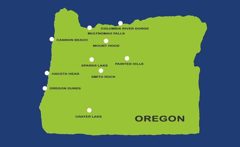
Commercial and recreational drone pilots agree that Oregon has many beautiful places to fly drones. In fact, here are just some of the most popular location areas:
- Abiqua Falls – This stunning waterfall located in the foothills of the Cascade Mountains offers a picturesque setting for drone photography, with its moss-covered rocks and emerald-green pool.
- Alvord Desert – This expansive desert in southeastern Oregon offers breathtaking views of the surrounding mountains, as well as the opportunity to capture footage of remote wilderness areas.
- Bandon Beach – This iconic beach on the southern Oregon coast features stunning rock formations, dramatic sea stacks, and beautiful sunsets that are perfect for capturing with a drone.
- Cannon Beach – This picturesque beach on the Oregon coast offers dramatic rock formations, pristine sand, and stunning sunsets that make for unforgettable drone footage.
- Crater Lake National Park – With its crystal clear blue waters, towering cliffs, and snow-capped peaks, Crater Lake National Park is a must-visit destination for drone enthusiasts.
- Columbia River Gorge – Known for its stunning waterfalls, scenic vistas, and steep cliffs, the Columbia River Gorge is an ideal spot to capture panoramic views from above.
- Heceta Head Lighthouse – Heceta Head Lighthouse is a historic lighthouse located on the Oregon coast that offers stunning views of the surrounding ocean and rugged coastline.
- Hells Canyon – As the deepest river gorge in North America, Hells Canyon offers dramatic views of rugged cliffs, winding rivers, and remote wilderness areas.
- Hood River Valley – This scenic valley in the Columbia River Gorge offers views of orchards, vineyards, and snow-capped mountains, making it a great spot for aerial photography.
- John Day River – Known for its clear waters, rugged canyons, and abundant wildlife, the John Day River is a great place to capture aerial footage of Oregon’s wild side.
- Lost Lake – This remote lake in the Mount Hood National Forest offers stunning views of the surrounding mountains, as well as the opportunity to capture aerial footage of a pristine alpine lake.
- Mount Hood National Forest – With its rugged terrain, alpine lakes, and dense forests, Mount Hood National Forest offers plenty of opportunities for aerial photography.
- Multnomah Falls – This iconic waterfall is a popular tourist destination that offers stunning aerial views of the surrounding landscape.
- Oregon Coast Trail – Spanning the entire length of the Oregon coast, the Oregon Coast Trail offers numerous opportunities to capture breathtaking aerial footage of beaches, cliffs, and sea stacks.
- Oregon Dunes National Recreation Area – Stretching along the coast from Florence to Coos Bay, the Oregon Dunes National Recreation Area offers stunning views of wind-swept sand dunes and coastal forests.
- Painted Hills – Located in the John Day Fossil Beds National Monument, the Painted Hills feature unique, colorful rock formations that are a favorite among drone pilots.
- Rogue River – This scenic river winds its way through southwestern Oregon, offering breathtaking views of rocky canyons, lush forests, and abundant wildlife.
- Silver Falls State Park – With its numerous waterfalls, lush forests, and scenic hiking trails, Silver Falls State Park is a great place to capture stunning aerial footage.
- Smith River Falls – Located in the Siskiyou Mountains of southwestern Oregon, Smith River Falls offers dramatic views of cascading waterfalls and rocky gorges that are perfect for drone photography.
- Smith Rock State Park – This popular climbing destination offers breathtaking views of towering rock formations, deep canyons, and winding rivers that are perfect for drone photography.
- Sparks Lake: Located in the Cascade Range, offers stunning views of Mount Bachelor and the surrounding wilderness.
- Steens Mountain – This remote mountain range in southeastern Oregon offers sweeping vistas of high desert terrain, including rugged canyons and rocky outcroppings.
- The Three Sisters – The Three Sisters are a trio of towering peaks in the Cascade Range that offer stunning views of snow-capped mountains and alpine forests.
- Timothy Lake – Located in Mount Hood National Forest, Timothy Lake offers pristine waters, dense forests, and scenic mountain vistas that are perfect for aerial photography.
- Toketee Falls – This beautiful waterfall in Umpqua National Forest is surrounded by towering cliffs and lush forests, making it an ideal spot for drone photography.
- Wallowa Lake – Nestled in the northeastern corner of Oregon, Wallowa Lake is surrounded by towering mountains, alpine meadows, and pristine forests that are perfect for drone photography.
- Yaquina Head Lighthouse – This historic lighthouse located near Newport offers incredible coastal views, including the surrounding ocean and nearby cliffs.
Please note that drone regulations and restrictions may apply in certain areas (takeoffs and landings), so it’s important to check and follow the rules “before” you fly.
Oregon Drone Legalese: Take-Off and Landing Location Rules
Flying drones in Oregon is regulated by the FAA, and there are additional rules specific to Oregon. Drones can be used for both recreational and commercial purposes in the state, but are subject to local flight controls and FAA regulations. Get More Information
Oregon State Parks: Restrictions
As a point of reference pertaining to certain Oregon State Park restrictions. This actual email between OPRD and our agency provides some clarification:
Oregon Wilderness Areas
Oregon has 48 designated wilderness areas, spread across the state’s diverse landscapes.
Here’s the full list:
- Alder Creek Wilderness
- Badlands Wilderness
- Battle Creek Wilderness
- Boulder Creek Wilderness
- Cascade-Siskiyou Wilderness
- Cloud Cap Wilderness
- Columbia Gorge Wilderness
- Coyote Butte Wilderness
- Crater Lake Wilderness
- Devil’s Garden Wilderness
- Diamond Peak Wilderness
- Eagle Cap Wilderness
- Elkhorn Mountains Wilderness
- Fish Lake Wilderness
- Fremont Wilderness
- Glacier Peak Wilderness
- Greenhorn Wilderness
- Grizzly Mountain Wilderness
- Happy Valley Wilderness
- High Cascades Wilderness
- Hells Canyon Wilderness
- Indian Heaven Wilderness
- Iron Mountain Wilderness
- Kalmiopsis Wilderness
- Lake of the Woods Wilderness
- Lassen Volcanic Wilderness
- Milo Creek Wilderness
- Mount Hood Wilderness
- Mount Jefferson Wilderness
- Mount Washington Wilderness
- Muddy Creek Wilderness
- North Fork John Day Wilderness
- Opal Creek Wilderness
- Red Mountain Wilderness
- Rogue River Wilderness
- Saddle Mountain Wilderness
- Salmon-Huckleberry Wilderness
- Siskiyou Wilderness
- Sky Lakes Wilderness
- Steens Mountain Wilderness
- Three Fingers Wilderness
- Twelve-mile Wilderness
- Wallowa Mountains Wilderness
- Walton Lake Wilderness
- West Cascades Wilderness
- Willamette Wilderness
- Wind River Wilderness
- Yale Creek Wilderness
These areas are protected for their natural beauty, providing essential habitat for wildlife and a place for outdoor recreation. They span different ecosystems—from alpine peaks to river valleys, coastlines to dense forests.
Drone-Friendly Locations in Oregon
Exploring Areas Outside Wilderness Zones
There are several areas in Oregon where drone flying is allowed, particularly outside of designated wilderness areas. These locations may include national forests, state parks, or other public lands that are not protected as wilderness areas. Here are some options where drones are typically permitted, though it’s always a good idea to confirm local regulations before flying:
1. National Forests (Non-Wilderness Areas)
Willamette National Forest
While the forest itself includes wilderness areas where drones are prohibited, many non-wilderness regions within the forest allow drone flying. Areas around popular spots like the McKenzie River or Santiam Pass can offer great opportunities.Deschutes National Forest
This is another forest that has both wilderness areas and non-wilderness regions. You can fly drones in areas like Bend or Mount Bachelor (outside designated wilderness), which provide unique terrain for aerial photography.Umpqua National Forest
Like other national forests, Umpqua offers non-wilderness regions where drones can be flown, especially around popular recreation sites like Toketee Falls or the North Umpqua River.Rogue River-Siskiyou National Forest
Much of this forest includes wilderness areas, but outside these regions, there are numerous places to fly drones. Areas near the Rogue River are popular for scenic aerial footage.
2. Oregon State Parks
Harris Beach State Park
Located on the southern coast, this park offers dramatic ocean views and rugged coastal landscapes. Drone flying may be permitted here outside of protected areas.Ecola State Park
Near Cannon Beach, this park has incredible ocean views and towering cliffs, with non-wilderness sections where drones are allowed (outside protected areas).Bandon State Park
Known for its iconic sea stacks, this park offers coastal views that would be amazing from the air, and drone flying is typically allowed in non-wilderness sections.Silver Falls State Park
While the park is known for its waterfalls, many of the surrounding areas allow drones outside the designated wilderness or natural areas.
3. Bureau of Land Management (BLM) Land
Oregon Dunes National Recreation Area
The BLM-managed Oregon Dunes offers a vast expanse of dunes and coastal habitats where drones can be flown, provided it’s not within restricted zones or wilderness areas.The John Day River
This BLM-managed area is known for its unique landscapes, and drones are permitted in many areas surrounding the river, though it’s essential to stay clear of sensitive wildlife zones.
4. Other Locations
Columbia River Gorge (Non-Wilderness Areas)
While much of the Gorge is protected, there are regions outside the Columbia River Gorge National Scenic Area where drone flying is allowed. Areas such as Rowena Crest offer stunning aerial views.Smith Rock State Park
While the park itself can be crowded with rock climbers and hikers, there are areas around Crooked River where drone flying may be possible, as long as it doesn’t interfere with the park’s visitor experience.
General Guidelines:
- Proximity to Airports: Always check airspace restrictions around airports, especially near large cities (Portland, Eugene, etc.).
- Wildlife Areas: Be cautious around wildlife refuges, as they often have restrictions on drone use to avoid disturbing animals.
- State and Federal Regulations: Make sure you’re in compliance with FAA regulations and local rules.
If you’re unsure, always check with the managing agency (e.g., U.S. Forest Service, Bureau of Land Management, State Parks) for the most up-to-date drone flying rules in specific locations.
Essential Resources for Exploring Oregon’s Wilderness
Here are some key resources you can use to learn more about Oregon’s 48 designated wilderness areas, as well as to explore them responsibly:
1. U.S. Forest Service (USFS)
The U.S. Forest Service manages many of Oregon’s wilderness areas, especially those located within national forests.
- Website: US Forest Service
- You can use the website to find detailed information about specific wilderness areas, including regulations, maps, and guidelines for outdoor activities.
2. Bureau of Land Management (BLM)
The BLM is responsible for managing public lands that are not under the jurisdiction of the Forest Service. Some wilderness areas fall under BLM management.
- Website: BLM Oregon
- The BLM site provides information on wilderness areas, maps, recreation opportunities, and regulations for areas they oversee.
3. Oregon Wilderness Coalition
The Oregon Wilderness Coalition advocates for the protection of wilderness areas in Oregon and provides resources on the state’s wild areas.
- Website: Oregon Wilderness Coalition
- They offer educational materials, updates on wilderness protection, and insights into the history and management of wilderness areas.
4. Oregon State Parks
While Oregon’s state parks are not typically wilderness areas, some are adjacent to or overlap with wilderness zones. They also provide maps, regulations, and information on hiking, camping, and other outdoor activities.
- Website: Oregon State Parks
5. Oregon Natural Desert Association (ONDA)
ONDA works to protect Oregon’s high desert wilderness and offers resources on the wilderness areas within the state.
- Website: ONDA
- The site features advocacy, educational materials, and details on specific wilderness areas like the Badlands Wilderness and Steens Mountain Wilderness.
6. National Wilderness Preservation System
A national-level resource for understanding the history, legal aspects, and management of wilderness areas in the U.S., including Oregon’s designated wilderness areas.
7. Recreation.gov
For those looking to visit wilderness areas for recreation, such as hiking or camping, this site provides information on permits, reservations, and details about specific locations.
- Website: Recreation.gov
8. Oregon Hikers
A community-driven website with a wealth of information about hiking, including detailed trail descriptions, wilderness areas, and outdoor activities across Oregon.
- Website: Oregon Hikers
- These resources will provide you with maps, regulations, and other helpful information to explore and respect Oregon’s beautiful wilderness areas while enjoying outdoor activities.
The Takeaway
The capstone of this discussion is to zero in on “the where” drone flight is permitted in Oregon. As of today’s date, we know that certain Oregon regulatory commissions are moving forward to better understand the industry in an effort to help coordinate and regulate which drone pilot is flying where, how high, how far, and when. For example, Smith Rock State Park rangers have expressed concerns with wildlife invasion and the increasing number public complains received some outdoor enthusiast consider drones flights in these park areas to be a disruptive annoyance.
While overwhelming positive public sentiment may still be a few years away, some of Oregon’s key influencers at city, county, and state level are now at work to help recreational and commercial drone pilots and the public at large more clearly define the boundaries of, “Where Can You Fly Your Drone In Oregon?”
Footnote On Public Sentiment: As is the case with any novel concept or innovation, achieving broader public recognition and global acceptance for drone flight will require effective communication and a significant amount of time.
In conclusion, while there is still some confusion and regulatory work being done, Oregon drone pilots can fly in controlled and uncontrolled airspace, and resources such as the FAA’s B4UFLY app and LAANC applications can help determine where it is legal to fly. However, it’s important to conduct pre-flight planning and be aware of local regulations, especially in areas such as state parks. With ongoing efforts by regulatory commissions, the boundaries of where drones can fly in Oregon will continue to become clearer.
Next article we focus on the difference between recreational and FAA Part 107 sUAS certification.
Be smart, safe, and forever fly!
If you have any questions, let us know! If you’d like to hire us, you can get more information here.
Written by: Tony Marino, MBA – FAA Certified Part 107 Commercial Drone Pilot and Chief Business Strategist at Aerial Northwest
This article is intended exclusively for general informational purposes only and should not be construed as legal advice.
Reference Resources
- Article: Oregon State Parks Are About to CHANGE Drone Rules FOREVER
- Drone operations in Oregon state parks. OPRD.
- Drone Map Classification Criteria
- Drone Laws in Oregon
Starting Your Own Drone Service Business
Pick up your copy today on Amazon and wherever fine books are sold.

DRONE BUSINESS STRATEGY MAGAZINE
A free digital publication made exclusively for all small business drone pilots to them help start-up, become profitable while sustaining a competitive advantage within the drone service industry sector they opt to serve.
“If you love to fly, we’d love to have you come aboard!”
We share your information with no one. Our Privacy Policy.


4 Comments
Leave your reply.